June 3, 2018

Bath Freestone Workings, book

In 1984, I published a book I had written, "Bath Freestone Workings".

Reviews appeared in local papers,

January 30, 2018

Salt Mine at Berchtesgaden, Germany

I was in Salzburg in Austria and we had a chance to go to a salt mine. I thought we were going to the Hallein mine in Austria, but instead we went to the one in Berchtesgaden in Germany.

Salt has been mined in Berchtesgaden since the 12th century. The current salt mine has been operating for 500 years (1517). The Salt Mine employs approx. 100 employees. Half of these work underground.


It was a really fun and interesting tour, although sadly no photography is allowed. First everyone is given overalls to wear and bags and coats must be placed in a locker. Then there is a 650 m train ride into the mine. The non German speakers are given a recording to listen to in each relevant section. From the train we walked into the Salt Cathedral and did the first slide down to the lower level. This was great fun, up to 4 people at one time going down the steep 34 m slide. We went through some tunnels and saw a grotto in honour of King Ludwig II.

We moved into a room and were shown a film on salt mining with a display on a 3D model. I hadn't realised the salt is extracted as brine, it is not cut in blocks. The salt does not occur in a pure form, but is encased in “Haselgebirge”, a composite rock contains an average of 50% salt.

Salt deposits are proven to be up to 300 m below the valley floor in the area of the Salt Mine.  It is released from the mountain with the aid of freshwater using a “wet mining” method. Hollow spaces are created, then water is pumped into these voids, this water removes the salt from the composite rock on the floor, walls and ceiling. The salty water is denser so sinks to the bottom. It has a 26.5% salt content. The hollow space is constantly enlarged as more fresh water is fed in. This process is repeated until a 3,500 to 5,000 cubic metre hollow space is formed.

At five mining levels, 20 state of the art so called mud-flush drilling plants are in operation. Approx. 900,000 m³ of brine are extracted per annum. 2.000 m³ of freshwater are required for this each day.

The brine is pumped up to the surface and to the refinery where the water is extracted leaving pure salt. The Berchtesgaden brine is pumped to the Salt Works Bad Reichenhall further processed into industrial salts there.

Down to 400 m depth below the mining route level, samples are taken by drilling in order to ascertain the minimum salt content in the rock.

We went through more tunnels and saw the airlift drilling equipment. Next stop was the Magic Salt Room. In the centre of the room is a container of large salt crystals and different colours are played onto the salt, then a series of stories relating to the mining are screened on to the walls. It was very effective.

We then took another slide down to a lower level, this slide is 40 m. We came to a large chamber and initially I thought it was empty until I realised there was actually a lake. The ceiling is perfectly reflected in the water. We crossed the Mirror Lake on a large wooden barge, with the accompaniment of music and lights displays of salt chemical structure played on the walls. We saw a pump that is used to lift the brine to the surface, it is made of bronze. One of the old pumps used to lift the brine up 356 m. The brine was then sent in wooden pipes from Berchtesgaden to Ramsau.

Next we took an elevator back up 2 levels and took the train journey back out of the mine.

The slide (internet photo)

For photos and more information, see The Salt Mine Berchtesgaden.

December 2, 2017

Bats and SARS in China

In 2002-2003 an outbreak of SARS killed almost 800 people around the world. The virus, severe acute respiratory syndrome (SARS) is a pneumonia-like illness and was first noticed in Guangdong province, southeastern China.

Scientists found genetically similar viruses in masked palm civets (Paguma larvata) sold in Guangdong’s animal markets. It was later found that similar viruses were in horseshoe bats (Rhinolophus) in China. It was thought the deadly strain probably originated in the bats, and later passed through civets before reaching humans.

This led to sampling horseshoe bats around China. In a cave in Yunnan, scientists found a strain of the virus similar to the human version. They then spent five years monitoring the bats that lived there, collecting fresh guano and taking anal swabs.

After a lot of research virologists have shown that this single population of horseshoe bats harbours virus strains with all the genetic building blocks of the one that jumped to humans in 2002. They published the news in Nov 2017.

This leads to questions. How can a virus from bats in Yunnan travel to animals and humans around 1,000 kilometres away in Guangdong, without causing any suspected cases in Yunnan itself. Also can
the human SARS strain jump from bats to another animal, such as a civet.

The scientists have to continue their search for other bat populations that carry the same strain of virus.

In the meantime there is the worry that the deadly outbreak could reappear. The cave with the affected bats is only 1 km from a village.

The Chinese authorities have closed many markets selling animals in China since the outbreaks of SARS and other infectious diseases. I really wonder if this is effective, or enforced.

See my blogs on bushmeat in Laos :
Laos markets
Laos bushmeat,
Luang Prabang market 

These photos were all taken in northern Laos in 2007 and 2008, relatively close to the Chinese border and Yunnan!

See the main article on bats and SARS in Nature 1 Dec 2017, "Bat cave solves mystery of deadly SARS virus — and suggests new outbreak could occur".

October 20, 2017

Huge cave found on the moon

A huge underground cave has been found on the moon, opening up the possibility for astronauts to take shelter there in future missions. The Japan Aerospace Exploration Agency (JAXA) made the ground breaking discovery and announced it overnight. This was reported in ninecom.au news on 19 Oct 2017. The report also has pictures of the cave.

The entrance to the cave as seen from above the surface of the moon. (JAXA)

The cave is about 100 m wide and stretches 50 km across the moon's surface according to data collected by JAXA’s moon probe called the Selenological and Engineering Explorer (SELENE).

A 50m wide opening to the cave was first discovered by SELENE in 2009, and was analysed over the following years.

Data confirmed the cavern was likely created by a lava tube formed during volcanic activity and there is a chance ice or water exists in rocks inside it.

Scientists hope future moon explorers could use the cave for protection from the sun's radiation and cosmic rays. It could even act as base for the explorers and if there is water or ice to found inside, it could be used as fuel.

Scientists widely believe the moon experienced a series of large-scale volcanic activity up until about one billion years ago.

The cave, believed to be a lava tube created about 3.5 billion years ago
See more on Japan Times 18 Oct 2017.

August 25, 2017

Rock art in Cuba

News of a new cave painting site in Cuba was announced in August 2017. I went to Cuba in 2015 and wasn't aware of any rock art.

The news item "Speleologists Discover New Cave Painting Site in Cuba" can be seen here. It says that 'Cuban speleologists have discovered a new cave painting site in a cave located at the Sierra Maestra mountain range, in southern Granma province'.

The mountains have a long history of guerrilla warfare, such as the Cuban Revolution and Cuban Wars of Independence, including the time when Fidel Castro hid in the area with his supporters. Map from Wikipedia -

I was in Santiago de Cuba province and saw the mountains, they are volcanic -


The rock art consists of a group of pre-Columbian petroglyphs (carvings or incisions made in the rock). These engravings are the first ones reported in that area of Cuba. Photo taken from Prensa Latina -


The discovery is particularly important because the seven cave painting sites previously identified in that province are located in the western extremity, near Cabo Cruz. Wikipedia map -

August 12, 2017

Great Orme bronze age mine, Llandudno

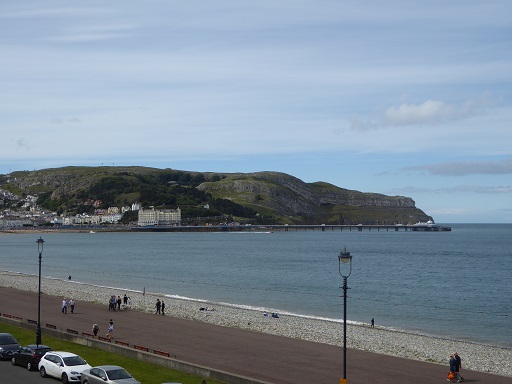
I used to visit the Great Orme on holidays in the 1960s. At that time I didn't realise it was limestone. I revisited the Great Orme in 2017. I was also able to visit the copper mines, which were only discovered in 1987.

The ancient copper mines on the Great Orme are located in Carboniferous Limestone formed around 330 million years ago. Their discovery in recent years meant the history of the metal age for Britain had to be rewritten, as it was found that mining of the copper ores began in the early Bronze age around 4000 years ago and continued until around 600 BC. This is earlier than first thought.


The above poster says "Mining on the Great Orme began around 4000 years ago. The earliest mining was open-cast, where the green copper ore malachite was exposed on the surface. Hundreds of tonnes of ore were extracted from these surface workings before the miners eventually had to follow the ore below ground. Bronze Age miners had a variety of tools available to them. Specially chosen stones from the beach would have been used as hammers, and animal bones would have been used as chisels and scrapers. Over 2,500 stone hammers and 35,000 bones have been found at the mine."

Mining recommenced in the late 17th century and continued into the 19th century. The main mining area was near the halfway tram station, where shafts and spoil tips can still be seen. Since their discovery in 1987, mining engineers, cavers and archaeologists have mapped the tunnels of the ancient workings as well large areas of the surface landscape, revealing remnants of bell pits aligned with geological faults.

Today the Great Orme Bronze Age Mine is a tourist attraction. It is located close to the halfway station of the tram. It is a self guided tour, starting with a short film. Then you can explore some of the workings, and find out more about life of the Bronze Age miners.


The miners worked underground for more than 1000 years, reaching depths of 70 m (220 ft) below ground. The tunnels were mostly very narrow, many of them were only big enough for children to work in. For lighting they used animal fat lamps or candles.

Entrance to the underground section that is open to tourists.


Looking at a very small passage that would only have been accessible to children

The basic tools of prehistoric miners, found when the ancient mines were rediscovered in the late 20th century, were stone hammers, animal bones and antler picks. Mining was such hard work that the ore-bearing rock was roughly sorted underground and only the ore was taken to the surface. The waste rock was stored in abandoned passages.

When the rock was not too hard, fires were lit to weaken it. The charcoal remains from these fires have been carbon dated, confirming that the mining took place between 3000 and 4000 years ago.

This is thought to be the largest chamber to exist in an ancient mine


One shaft open to the surface is 145 m deep! It goes down to sea level.

You can see an explanation on how the ore was smelted in kilns reaching 1100 degrees C.

It is amazing to think that the site lay entirely hidden for decades, being covered with spoil. The photo on the left shows the site in 1987.

Currently over 5 miles of tunnels have been found, making this the largest known Bronze Age copper mine in the world.

See and read more on the mine www, greatormemines . There are some good photos, a video and lots of info.

Great Orme, Llandudno, North Wales

As a child I had several holidays in north Wales and each time we would visit the Great Orme at Llandudno. However in those days I had no interest in caves and knew nothing about the geology. The Great Orme is in fact limestone. It is a large outcrop of Carboniferous limestone, approx 365-325 million years old.

Across Llandudno bay is the Little Orme which is also limestone.

Google Earth image of the bay with the Great Orme on the left and Little Orme on the right -

The Great Orme is 3 km long and 2 km wide, and rises to 207 m at the summit. It is protected as an SSSI and a nature reserve. It has important habitats for fauna and flora. It has farmland, also a growing herd of feral Kashmeri goats.


There is a road around the Great Orme. Or you can walk up. Otherwise you can take the cable car or the tram to the summit. I did both. They are run by different companies so you have to pay separately for each, so I did the return journey on the cable car, then did the return journey on the tram. With the tram you have to change trams at the halfway station so that gives an opportunity to go to the Bronze Age mine as it is nearby.


Geological features include the limestone pavement. There are also caves but as far as I can tell, none are particularly 'exciting' and are not easy to get to. Some are connected with the copper mines on the headland. See more on the caves.


The limestone is locally dolomitised. Copper mineralisation and dolomitisation are closely associated with fractures and faults. Hydrothermal fluids passed through the fractures creating veins of copper and other minerals.

Dozens of pits dug by miners -


When I visited the Great Orme as a child in the 1960s, the copper mines hadn't been discovered. They were only found in 1987. So on my next visit in 2017 I was able to visit one. See my next blog on the Great Orme Bronze Age Mine.

***