Showing posts with label Australia. Show all posts

March 18, 2014

Chillagoe caves, Australia

In 1988 I was living in Cairns, north Queensland, Australia. I did several caving trips to the Chillagoe area, which is in the outback, 215 km west of Cairns. Some of the caving trips were with the Chillagoe Caving Club, others I was working as a cave guide for a Cairns tour company.

Chillagoe is a small outback town, this is the post office -

Some of the caves are beautiful with many formations.

These photos are not good, as I don't have a scanner, so just took photos of the photos!


I was incredibly lucky to visit Bugrake Cave as it is normally closed, owing to the beautiful formations. The small entrance is in a hillside and starts as a 55' pitch. The cave consists of 3 beautiful chambers, with masses of stal, a pure white floor, a ceiling covered in thousands of stals, straws and some huge helictites as well as tiny ones, pools, small gours etc. It was just wonderful. The cave is in good condition and the stal is clean, the only real damage being to the floor. The cave was hot. These photos are Bugrake Cave -


This cave is CH123 Ryans Creek - A very pretty but short cave. Almost a walk in entrance over boulders then into a large passage with coral, stal, a large curtain, bats and spiders. There were some long tree roots hanging down.


See my article on Chillagoe in the Brunei Times 2008.

March 17, 2014

Undarra lava tunnels, Queensland, Australia

The Undara [Undarra] Volcanic National Park is situated in central Queensland about 350 km south west of Cairns, Australia. It is important for its geology and ecology. There are many lava tubes and caves, formed after a huge volcanic eruption that occurred 190,000 years ago.

Undara is the Aboriginal word for 'long way', and perfectly describes the isolated Outback Australian
location. This part of Queensland is dry savanna woodland but the area around the caves has green rainforests with semi-evergreen vine thickets and perennial springs. These freshwater perennial springs support a variety of wildlife, such as kangaroos, wallabies, birds, frogs and snakes.


The Undara lava tubes are some of the longest in the world. According to Wikipedia, Bayliss Cave is over 1300 m long, and has bad air.

They are home to many bats, of 4 main species. Today tourists are taken to the mouth of Barkers Cave to watch the nightly bat exodus when they leave the cave to feed.

 I visited 2 of the lava tunnels in Nov 1988. From Cairns we drove up the Gillies, through Malanda and Mt Garnet and Yaramulla, then 23 km through the bush to Undara.

These photos are poor as I didn't have a scanner so just took photos of the photos!

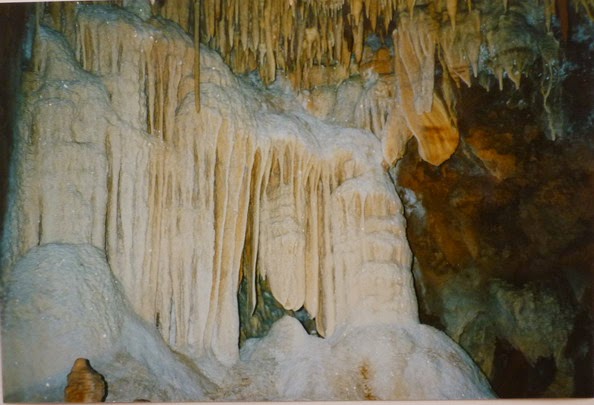
Outside the only signs of it being a volcanic area are the brown magma stones. These have lots of holes.

Bayliss Cave is the longest in the Undara system. Bayliss has a small entrance in a small depression. The entrance collapse led into the tunnel proper, and we had to go past 2 dead and smelly possums. The passage is a uniform almost circular tunnel, about 25' high x 30' wide. It was reasonably straight and had a dried mud floor. The roof lowered in places.
 Eucalyptus roots hanging in the cave


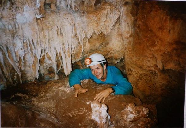
There are a few bats. We came to a raised pile on the floor and beyond was some very glutinous and slippery mud like chocolate mousse. The roof lowered but the passage continued.


We drove to Barker Tunnel. This is near a hill capped with large boulders. Everyone (except me) wanted to dive in this cave as they were expecting a nice lake.


The entrance is large and a boulder slope leads down into the tunnel which is larger and straighter than Bayliss.

As we went through we disturbed a few bats then heard a sound like a waterfall which we soon realised was flying bats. Soon after a whole colony flew towards us and it began raining bat pee and poo! The stench was awful. The bats filled the air and it was an amazing sight. The floor became liquid guano and was revolting. We stopped when it got above shoe level.

It looked like the beginning of a lake in front so Carl waded out for a look, resulting in the 3 guys deciding to dive. We went back out to get the equipment and I was glad to be in  the fresh air. They inflated their boat at the entrance and carried it in.


 Remains of a kangaroo -


I wasn't really sure what the others were going to dive, but 3 of them kitted up and set off, using the dinghy as a sled. The rest of us waited in the bat shit. The divers disappeared around a corner but were never out of earshot. They didn't get further than upper thigh depth when they came to the end of a passage - a wall.

Apparently 10 years ago, a 2.5m lake had been dived, so obviously the water levels are now much lower indeed.

Some tunnels are home to a virulent lung fungus and in addition there is the strong smell from the bats, not to mention histoplasmosis, so I stuffed tissues up my nose!

After the trip, this was the only way we could wash, as there is a lack of water in the area -


sharing a plastic box


See more on Undara tunnels.

June 8, 2008

Chillagoe

Published on The Brunei Times (http://www.bt.com.bn/en)

Chill in Chillagoe for a taste of the real Australian Outback
Liz Price

CHILLAGOE, AUSTRALIA

Sunday, May 18, 2008


KANGAROOs were bouncing across the road and a flash of bright colours in the trees ahead indicated the presence of cockatoos. The blue sky contrasted sharply against the brown earth. This was bush country, the real northeast Australian outback.

In the dry season here in Chillagoe, everything is brown. There is no other colour except for the cloudless blue sky. The creeks are bone dry, the cattle painfully thin, and there is not a drop of water to be seen. But the harshness of the landscape is somehow fascinating, especially knowing that everything is lying dormant, waiting for the rains.

And when they come it is a different world. The wet season is from November to March and the whole landscape is transformed. Everywhere is green. The bushes and trees all develop leaves, there is grass where previously there had just been dusty earth, and even flowers are blooming. The creeks are all running and often the roads get washed out. The rivers overflow their banks and flood huge areas, and you realise why the locals warn visitors never to camp near a riverbed. Flash floods are so common.

Chillagoe lies about 200km from Cairns at the southern end of the Cape York peninsula in a landscape totally different climatically and geographically from Cairns. The limestone area of Chillagoe comes as a great surprise. I first saw the towers jutting out from between the trees. As we got closer the rocks appeared to rise vertically from a jumble of cracked and broken boulders to end in enormous jagged ramparts standing clearly out against the tropical blue sky. It is like a scene from a film set, and is similar to the limestone area of Guilin in China.

The Chillagoe limestone is noted for its sharpness, and this is an understatement. Razor sharp edges cover every surface, and I can see why the area has been likened to the Mountains of Mordar in Tolkein's Lord of the Rings. House sized boulders are jammed in crevices and every- where there are holes, some leading into caves, others just into impenetrable fissures.

Chillagoe is now an area of National Parks, divided into nine separate areas within a 16km radius. The two largest parks are Royal Arch and Donna Cave. They consist of limestone bluffs which are honeycombed with caves, rising from an undulating plain.

The plain is open woodland and grassland with trees such as ironbarks, bloodwoods, and ghostgums. On the bluffs are fig trees and helicopter trees. The leaves of the latter give a nasty sting. Many trees have roots which extend deep into the caves in an attempt to search for water.

Various caves are open to the public, and the more intrepid can go adventure caving. But apart from the caves, Chillagoe is noted for its aboriginal paintings, its smelters and its marble. As recently as one hundred years ago, the area was inhabited by aborigine tribes who made use of the relatively reliable water supply (the climate is drier today) and hunted the wallabies and other small mammals. They drew rock paintings of spirit figures and animals and they made hand stencils. The spirit figures were thought to represent deities inhabiting the caves. Thus people themselves stayed away from the caves.

The first white settlers encountered fierce resistance from the aborigines in the 1880s and many bloody battles were fought. The first settler, William Atherton, built his homestead at Chillagoe Creek. He and his family explored the caves. An aborigine girl was murdered by one of his stockmen and her body was thrown down a cave — her spirit is said to haunt the area, now known as Haunted Tower. Atherton sold his cattle to the miners who were beginning to flock to the area, prospecting for gold, silver and copper.

The mining boom lasted fifty years, and Chillagoe grew into one of the biggest mining centres of Queensland and at its peak in 1917 it had thirteen hotels, two newspapers and a hospital to cater to the population of 10,000. Today there are about 200 people. The workings were closed after WWI, and the smelters fell into ruin. Today, marble quarrying is the main industry. The Parliament House in Canberra contains genuine Chillagoe marble, which was sent to the marble area in Italy for finishing before being shipped back to Australia.

Tourism is also a thriving industry as people come for the cave tours, and also to experience the beauty of this stark landscape.The Brunei Times

--------------------------------------------------------------------------------

Source URL:
http://www.bt.com.bn/en/en/travel/2008/05/18/chill_in_chillagoe_for_a_taste_of_the_real_australian_outback